All mobile maps work in thefree Avenza Map App.This map works without the need for cellphone or internet coverage. Mark your favorite fishing holes, record water clarity, water temperature, insect hatches and more. Navigate confidently, never get lost! Spend more time fishing and less time searching for where to fish.
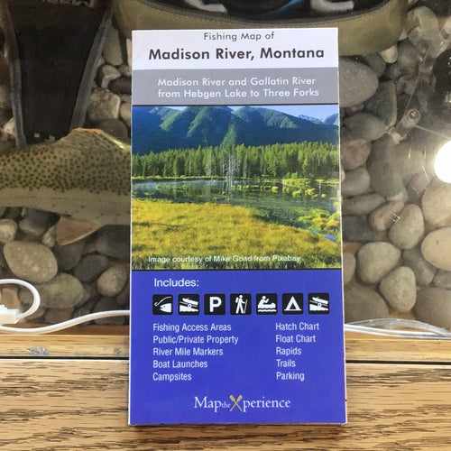
Our Madison River paper fishing map folds to a convenient 3" x 6" size, perfect for your tackle box or pocket. Unfolded size is 12" x 15" in full color and easy to read. A perfect reference for use when out on the water.
This map features the Madison River in Montana from Hebgen Lake to Three Forks, MT. It contains all public fishing access areas, picnic grounds, public restrooms, campgrounds, boat put in locations, parking areas, Forest Service Public Land and BLM Public Land. Also included are insect hatch chart and float charts.
The Madison River is one of the most famous and recognizable names in western trout fishing. Thousands of anglers from all over the world flock to the Madison to fish its hallowed waters. In the fall, monster brown trout move out of nearby Hebgen Lake to spawn. This is perhaps your best chance to catch huge brown trout. The Madison also contains impressive numbers of mountain whitefish.
The Madison River rises in Park County in northwestern Wyoming at the confluence of the Firehole and Gibbon rivers, a location known as Madison Junction in Yellowstone National Park. It flows west then north through the mountains of southwestern Montana to join the Jefferson and Gallatin rivers at Three Forks. The Missouri River Headwaters State Park is located on the Madison at Three Forks. In its upper reaches in Gallatin County, Montana, the Hebgen Dam forms Hebgen Lake. In its middle reaches in Madison County, Montana, the Madison Dam forms Ennis Lake and provides hydroelectric power. In 1959, the 1959 Hebgen Lake earthquake formed Quake Lake just downstream from Hebgen Dam. Downstream from Ennis, the Madison flows through Bear Trap Canyon, known for its class IV-V whitewater. The Bear Trap Canyon section is part of the Lee Metcalf Wilderness area.